D'Aleo- Happy 2012- Looking Back at the Carolina Crusher 13 years ago
January 1, 2012
This was a storm many will remember for its irony.
The day before the storm, General Kelly, Director of the NWS had in a press conference announced that the NWS had just implemented a 'supercomputer that together with the greatly improved model suite would ensure we would never again be surprised by a major storm. Famous last words, those models were suggesting a storm near the coast would stay offshore with minimal impact that very night and next day.
During the 6 p.m. news reports on Jan. 24, local meteorologists in the Washington, D.C., region forecasted "snow flurries" to begin around noon the next day with "up to an inch of accumulation on the ground." That was the last forecast many D.C. residents heard before going to bed that evening. But on Tuesday morning, Jan. 25, they awoke to find near blizzard conditions outside with 4 to 7 inches of accumulation already on the ground; and the winter storm wouldn’t subside until about 11 p.m. that night. In all, some areas east of Washington, D.C., received as much as 18 inches!
As the Capitol Weather Gang recalled in 2010: "All the operational forecast models routinely available at the time gave little, if any, clue to the imminence of this major weather event until late afternoon on the 24th. Even then, notwithstanding the fact that radar and satellite imagery appeared to indicate the area was in for at least a close call, since all models insisted on keeping the main area of precipitation to the east, the late-afternoon (4 p.m.) National Weather Service forecast for Tuesday called only for "Cloudy and Cold. Chance of snow...accumulation of an inch possible."
Likewise, the local early-evening broadcast meteorologists unanimously and categorically dismissed the possibility of a big snowstorm for Washington.
It was not until 10 p.m. that an official "Winter Storm Warning" was issued with the forecast now calling for 4-8 inches. Unfortunately, many folks had already gone to bed blissfully content that the next morning would dawn with a light accumulation of snow at worst and possibly nothing at all. Suffice it to say, when these same people arose the following morning to unexpected blizzard conditions, consternation was abundant. The snow lovers, on the other hand, some of whom surely stayed up all night monitoring the situation, welcomed the excitement of a raging snowstorm -- surprise or not!"
The pattern which had been characterized by a positive NAO and negative PNA in that second year La Nina had just flipped to a more threatening -NAO, +PNA, albeit temporarily,. The NAO took a dive negative on the 16th and the PNA flipped positive on the 23rd. Most forecasters were speculating about the very 'pregnant' situation and wondered whether a major snowstorm could develop before the NAO popped positive again which it did again on the 28th. The models could not bring it together.
.jpg)
The models were erratic but had said close but no cigar. The models expected a storm to develop but stay offshore. Here was the AVN from 48 hours before.
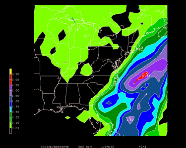
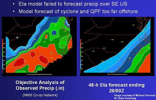
Here is the ETA model (right) versus the actual precipitation left.
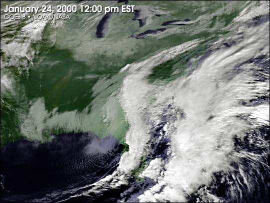
Meteorologists however were conflicted as the satellite imagery and even the radar was marching to a different drummer. A band of convection was seen well inland from the model forecasts on satellite and radar images revealed a vast blob of precipitation (mostly snow) being dumped on Georgia and the Carolinas at a rapid rate of accumulation on the ground..
Basic meteorology with a 300mb like this suggested trouble. But unfortunately too many trust the models too much and don't get down to basics and verify model forecasts and adjust accordingly.

Too many ignored the radar and satellite and trusted the models, assuming surely the model this close to the event could not be that wrong.
.jpg)
.jpg)
Here was the satellite view of the snowcover left behind after the storm passed, a testament to the statement that"...it isn't over til it's over".
.jpg)
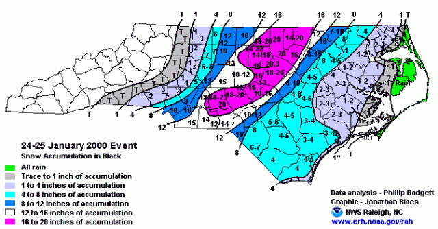
The all time single storm snow accumulation record for Raleigh-Durham was set with this storm when the airport received 20.3 inches of snow. Over 100,000 customers were without power and many schools and business closed for several days.
As the NWS summarized: The storm was not well forecast by numerical weather prediction models..Following the event, research at NC State indicated that the inability of the operational models to resolve antecedent precipitation across the Deep South was a major reason for their forecast failure of the developing cyclone.This event reinforces the need for forecasters to maintain situational awareness of upstream conditions and to compare model forecasts with observations.
By the way that La Nina winter (1999/00), did not rank in the top matching years when we did our winter forecast but has risen when the solar spiked more in November and the AMO cooled faster.