D'Aleo- NAM or AO Explains Recent Winters and Supports 2011/12 Forecast 14 years ago
Most of you are familiar with the Arctic Oscillation or AO by now. It has another name, the NAM Index or NAMI.
The monthly NAM index (NAMI) or AO index (AOI) is defined as the difference in the normalized monthly zonal-mean sea level pressure (SLP) between 35N and 65N.
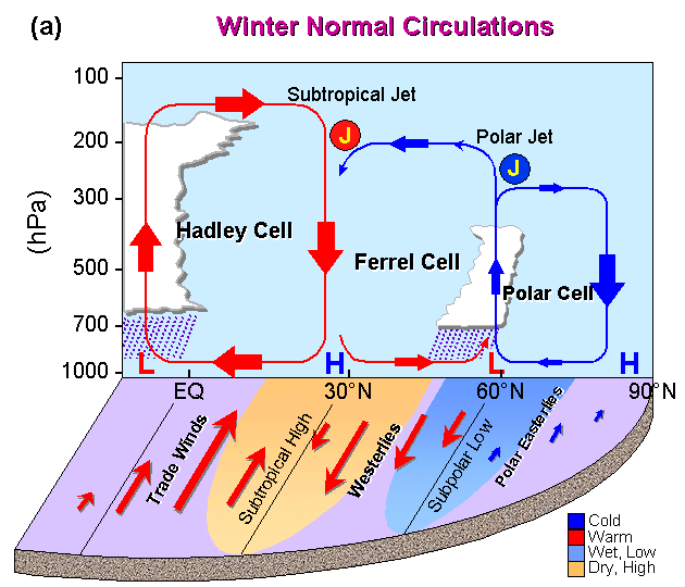
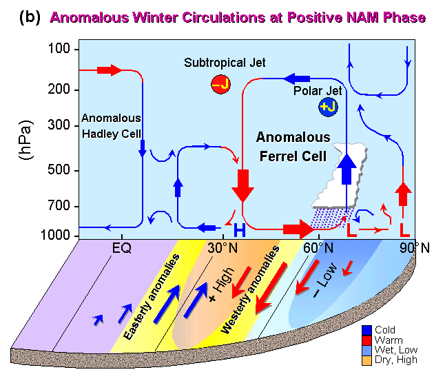
In the positive NAM phase, the Northern Hemisphere (NH) winter circulations are characterized by: low-pressure anomalies throughout the polar region, high-pressure anomalies across the subtropical and mid-latitudes, stronger-than-normal surface westerlies across midlatitudes, weakened subtropical jet and strengthened polar jet, positive temperature anomalies over midlatitudes in troposphere, negative temperature anomalies over polar cap in the upper troposphere and lower stratosphere, increased Ferrel Cell (FC) with a maximum anomalous ascent near 65 degrees N and a minimum anomalous descent between 35-40 degrees N. It also features reduced polar cell and a split Hadley Cell with enhanced south wind over subtropical and mid-latitudes, with enhanced baroclinity in higher latitudes and weakened baroclinicty in subtropical zone. The opposite conditions exist in the negative mode.
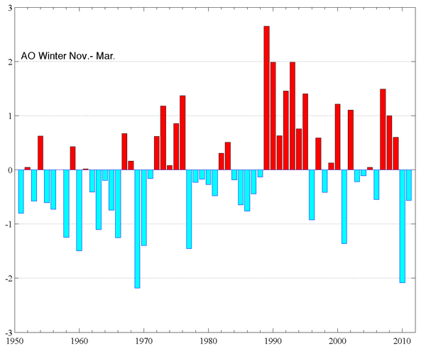
The University of Washington note that the NAMI or Arctic Oscillation (AO) is an important Arctic climate index with positive and negative phases, which represents the state of atmospheric circulation over the Arctic. The positive phase (red) brings lower-than-normal pressure over the polar region, steering ocean storms northward, bringing wetter weather to Scotland and Scandinavia, and drier conditions to areas such as Spain and the Middle East. The negative phase leads to enhanced polar high pressure and suppressed westerlies. Cold air from Siberia streams west to western Europe in winter bringing snows. In North America, the cold air is suppressed south with enhanced storminess, often in the form opf snow in the east.
While the value of the AO index was strongly positive in the early 1990's compared to the previous forty years, the value of the AO has been low and variable for the last nine years. The year to year persistence of positive or negative values and the rapid transition from one to the other is often referred to as "regime-like".
.jpg)
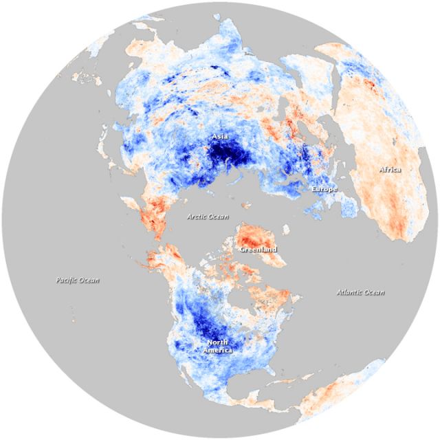
Extreme negative NAMI /AO states as in 2009/10 are even further south than shown in (a) for the cold.

You can see how with the trend from negative AO/NAO to positive from the 1950s and 1960s to mid 1990s, there was warming.
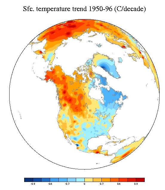
You can see how this is largely explained by the AO positive correlation.

See how that changed when the AO took a dive in 2009/10.
There is strong coupling of the tropospheric AO with stratospheric warming and cooling events which are driven in part by factors like the Quasi-Biennial Oscillation (QBO) and volcanism.
Look at the cross section in 2009/10 of the polar atmosphere. See the warmth there that results in high surface pressure with dense cold in low levels. The AO was off the chart negative.


Last winter started similarly but a very cold polar stratosphere and then troposphere developed in January with a corresponding positive AO.

An easterly QBO at 30mb correlates with a negative AO. The QQBO will be easterly this winter.

Most polar stratospheric warmings last 30-45 days and then fade. Last year it reversed. if it starts in Nofvember or early December again, that would lead to the front loaded cold we expect. But remember some winters like 2009/10 it returned of persisted. It may be the low solar, high latitude volcanism conspired with east QBO to persist the pattern in 2009/10.
The solar has bounced since then (though not high) and there has been no recent high latitude volcanism but the QBO is likely to become increasingly easterly over the winter. In the analog winters when that occurred, the late winter was not as warm in part because the classic La Nina blocking persisted longer. Also JB and I expect this La Nna to peak as moderate early then fade.That is why though we are confident about the cold start we have some concerns that these wildcards of a weakening La Nina and persisting blocking keep the typical late winter La Nina warmth from developing to a great degree.