Saturday Summary April 14, 2012 13 years ago
April 14, 2012
Dr Ryan Maue has joined our team and you have already seen some of what he can do as I have been using a lot of his maps. I have always been a big fan of his and for those of you not yet on Weatherbell Premium, as Ryan loads up the site with more and more unique ways of looking at the weather that you may not see anywhere else, you should give it a try. He Joins Joe D'Aleo and I with the expressed goal of buildling the greatest, go to "why behind the what" weather source in the world. Anyone can tell you what is happening now but we try to show you before and why. Of course, nowadays it's become popular to explain what happened after the fact, and then blame global warming. That is not what we are about. This outbreak has been on our radar for 10 days and has been referred to as the major outbreak of the month, though there could be a lesser, still formidable one next weekend. It is, as you know, April.
Obviously the biggest weather event will most likely be what is occurring Saturday with the severe weather outbreak, but there is a heck of a lot of weather going on in what is a de-amplifying pattern overall, but one that has some interesting tricks up its sleeve over the next 2 weeks
The major storm in the plains that is causing the outbreak also dumps snow in the rockies and in parts of the northern plains before heading off to the east with its cold front reaching the east coast on Tuesday. Snows tomorrow into Monday are confined the around Lake Superior, but it is the example I have been touting of how we would have some nasty cold come right back into areas where it was so warm

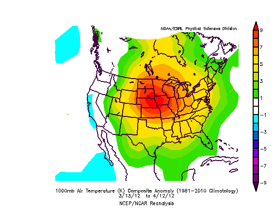
Last 30 days of temperatures:

A strong shot of hot is coming this week for Monday and Tuesday before this front and I have been touting this since last week, even the day snow was seen around DC, that it will try to hit 90 Monday! Not only is DC in for such things, but all the way to interior NJ could hit 90 Monday or Tuesday. With the ground bone dry and southwest winds, I think the GFS maxes are underdone here
from Dr Ryan Maue site:
.png)
Conversely, the cold in the northern plains after the current storm goes by means that early vegetation could get nipped.
From Dr. Ryan Maue's site:
.png)
In addition, we are likely to see a strong subtropical system develop in the altantic midweek, come back west for a while then turn northeast. This is being brought to light because there is a chance that the hurricane season could name somthing like this as it's liable to develop a warm core look Here is the 96 hour in the atlantic. The only reason I having been talking about this is because the naming protocal now of NOAA is such that they could name this and I don't want something coming out of nowhere.

The bigger problem though is in the day 8-12 period. A new storm reaches California and comes east across the country and this may phase along the east coast in the Sunday-Tuesday period. This storm may lead to severe weather in the plains later next week and the threat of a major buckling of the trough over the east in the 8-10 day period
The ensemble Wednesday morning shows the flatter look overall:
.gif)
But is replaced by the stronger looking trough after that:
.gif)
Once again we saw the GFS from last week too fast and too progressive on this and now it's catching on. Interestingly enough, such an event could lead to another attempt at snow in the mountains of the northeast in the Sunday-Monday period along with generous rains over the very dry mid and north atlantic states16 day amounts are generous.
.gif)
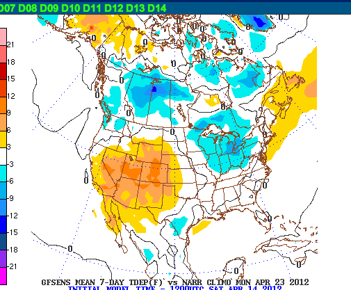
and 7-day running means ending the 23rd are quite chilly:

The day 8-10 means show the euro is not yet fully phasing the east coast system as it keeps it split, but I think there is just as good a chance of the phase as now. The euro actually doenst make sense with itself with the west coast trough that far offshore.
.gif)
but week two looks chilly in the east (if nothing else) and warm in the west.
The 288 progresses the storm offshore:
.gif)
and then a flatter look, in line with deamplification to end the month:
.gif)
NOAA's MJO page is down, but the Ensemble NAO and AO suggest we are not in a very warm pattern in much of the country in the longer term as they go negative.
.png)
.png)
The implication here is that while some warming is coming across, this is not March and that the week two period may have some problems, especially over the east.
Here is something I put out on what I think is a big discovery for hurricane forecasting and also something to draw attention to the biggest tornadic years.
Excerpt from a post earlier this week:
I want to thank the IPCC.
Because of their nonsensical trapping hot spot at 400 mb, and going back to show it's not there, it led to me to go and dig into hurricane seasons and guess what.. we have a nice correlation between the March 400 mb temp in the tropics and the ACE index.
I ran this by Dr Maue to see his comments. And this fits hand in glove with one of the more brilliant, though simple (perhaps that is why it is brilliant) theories about the weather I have ever heard, and that is the shadow effect of past events. In hurricanes, we will see a hurricane leave a "wake" of colder water and sinking air behind it where it's tough for another storm develop for several days. Well, with massive large scale events, its probably on the order of months.
Consider the lowest ace index years:
.png)
Massive cold in the tropical breeding grounds in March. If it warms, it would probably mean the air is drier than normal anyway. In any case, this is the March 400 mb preceding the lowest ace years.
Now look at this year:
.png)
Ouch!!!!!
Now look at the big years ( top 10)

This is huge. Notice how it's warm in the two areas of the Atlantic, in line with the idea we can have the Atlantic ventilated in two areas. In addition, the weak cool area shows the start of the TUTT, that is the key to big seasons. By putting a trough in the Atlantic that storms have to bust through, rather than wider sweeping troughs, you can create better jet dynamics for the threat of the storm busting through the trough, such as Andrew, Donna, Betsy, Gloria.. to name a few, and once on the other side of the trough, rapid intensification can take place.
Now this is going to get alot of people mad.. very mad. Why? Well think about it--if this is the magic bullet to the ace index, it will lead to quicker forecasts that everyone can make, rather than having to wait for the experts. But it's there.
So when the WeatherBELL team gets the Nobel prize for this, we will make sure we thank the IPCC. Without their nonsense on trapping hot spots, I may not have seen this.
Who says climate and weather don't mix?
There is another linkage to the cold there. Look at the years 2005 and 2010 when it was warmer aloft and there were less tornadoes, versus last year and 2008
.png)
This year we are a little warmer than last year, so we should not have as much as last year, which has been the forecast here.
Finally, as far as some of the global metrix to measure how we are all about to blow up the planet:
Global sea ice is near normal.
Northern hemisphere according to NORSEX is near normal:
.png)
Yearly global temperature is a bit cool:
.png)
April over normal:
.png)
Anyone see the need to push the panic button?
ciao for now