Saturday Summary April 28, 2012 13 years ago
A very different spring and summer is evolving as compared to last year as the high tide of warmth relative to averages this spring for the lakes and midwest as well as the northeast occurred early. Last May featured a western trough: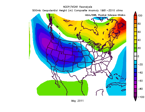
This year is very different and in line with what the Weatherbell has been tolling (I am getting to really like that). I think the idea we had in March to watch out for some of the antics we had to deal with in April were right. The best part of that foreacst was not going into a panic over tornado hysteria. Since the early March outbreak, we are below normal and in spite of 2 newsmaking events (one not even a major outbreak, but a problem because of where they hit), this April has one third the activity of last April and is under normal!
A look at tornado production so far
.png)
I have a post on our premium site on my research as to using 400 mb temperature trends to forecast the tornado season as well as a more startling discovery that I think wil turn out to be the biggest discovery in hurricane seasonal forecasting in years, so take a look at it if you can-they are very recent But both the tornado and hurricane season forecast incorporated this new idea, and right off the bat it's working. As far as the other idea, I believe the 400 mb temperature over the tropics in March is more important than the state of the ENSO and back it up with the fact that the two hyperactive el Nino years, 1969 and 2004, both had a signature at that level consistent with the high ACE years without el Ninos, while the la Nina years with low activiy had signatures consistent with the low ACE years at this level. In other words, the stronger correlation is the March 400 mb temperature south of 25 north in the Atlantic!!!!
There is a heck of a lot of research going on here, but we don't get paid for research, we get paid for the results. I try to always show people that are following us, right or wrong, the reasons of the why behind the what, and BEFORE, NOT AFTER OR DURING THE EVENT. In any case, both of these examples are way beyond just picking out a storm in a pattern, so yes, I am excited. This is probably something that Dr. Maue may play around with down the road to really see if it's what I think it is
But that may be an enticement to have you try our Premium, or if you are a company, our commercial site.. I am boring those subscribers now so I will move on (this is a free page issuance too).
I have been showing this as the May forecast for the commerical side since the end of March:
(2).jpg)
and may have to expand the cool, for after the shot of hot, tempearatures turn around a lot . The JMA weekly 500 mb shows the ridge coming out quick then the trough taking over in the east from the 5th on
week 1 week two 500
.png)
.png)
Week 3/4

After the shot of hot comes out we can see the major change going on in the surface temps in the cfs v2
the top is the 6-10, the bottom week two
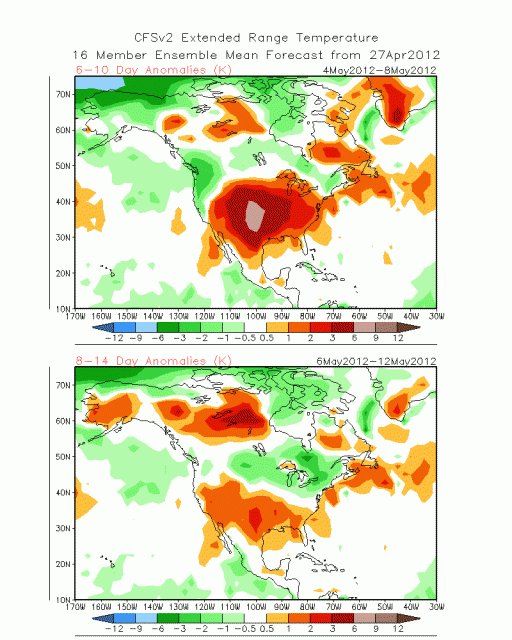
This continues week three and four:
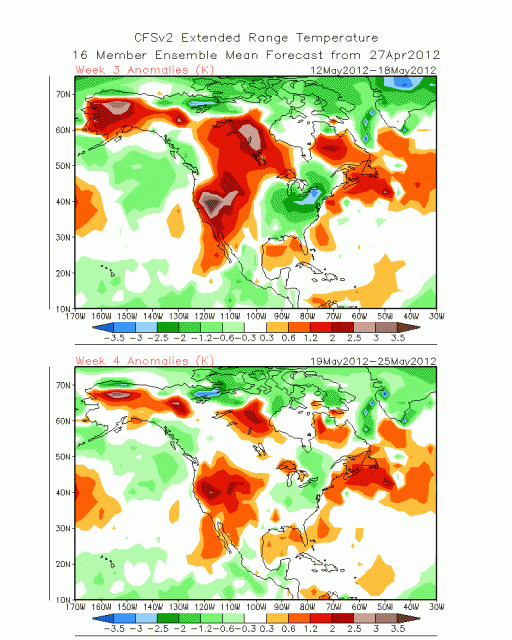
The implication is that from the Mississippi east, north of I-40, perhaps even I -20, the warmest temperatures of the month come this upcoming week. A look at the 500 mb evolution, week 1-4:
.png)
.png)
.png)
.png)
Precipitation with this: notice the heavy rains over Florida and the Bahamas in week one with the trough there now
Maps, week 1-4:
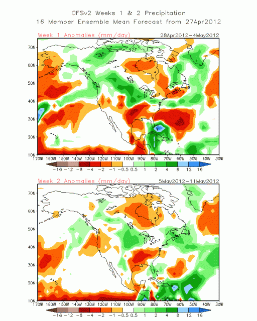
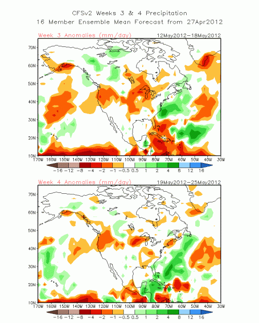
A lot of back and forth, but the biggest news is the trough backing in with the ridge in the west, and I expect to see alot of that during the summer. In addition, while the heavy rain in FLA is not a concern for the tropics, the heavy rain that develops the last week is, as there could be early season development this year.
While the support for cold from the major indices we look at for winter disappears at this time of the year, it appears the NAO and AO will go negative.
.png)
AO
.png)
Again the huge message is that the shot of hot will retreat into the west with a cool pool developing over the east.
In MJO land, look at how great the Euro is from a month out!
.gif)
It's true we got a bit too far into one, but look at where we are now:
.gif)
Not far away from where it said it would be a month ago. A look at the phases in May of the MJO and temperaturess and precipitation for you
.png)

You can refer to this when the MJO gains amplitude. For now it looks fairly feeble and that means we look at the other indices. Still, it appears the coming weeks are, after the hot shot warmer west and cooler east and the chance of a late month tropical troublemaker is on the table
As is my habit, a look at some global items:
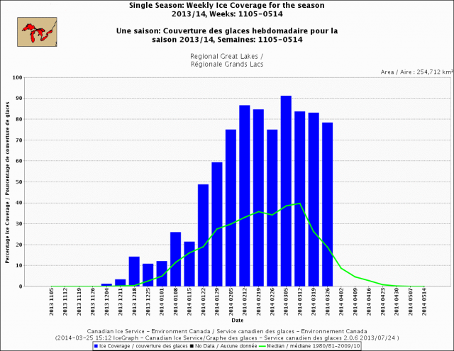
Sea ice:
3 yr global temp (courtesey dr ryan maue):
.png)
.png)
April
.png)
thanks for reading. Try out the Premium site and don't forget to listen to Wiseguys of Weather tomorrow night at 8pm EDT on Blog talk radio (www.wiseguysofweather.com).
ciao for now