Eclipse Forecast Update 7 years ago
August 15, 2017
Cloudcover forecasting almost a week in advance is imprecise, which is compounded by the relatively short window of eclipse viewing. The current forecast shows a fair amount of cloud cover during the transit, but much of it appears to be high clouds. This would still allow for viewing in most areas.
The clearest skies are expected to be in the Northwest and near the area with the longest dark period from southern Illinois to Kentucky. This is still almost a week away and changes are quite likely, but for now, this is the "best guess".
.jpg)
The same forecast when the higher clouds are filtered out is a little more promising in most areas:
.jpg)
It appears the region with the thickest clouds might be over the Rockies, with fair weather cumulus clouds likely skirting across the sky in the Southeast.
Note that in the absence of clouds, high moisture content can result in haze that inhibits viewing clarity. Areas in green are moist and brown areas are drier than normal for August 21:
.jpg)
Here is a still image of NASA's interactive page.
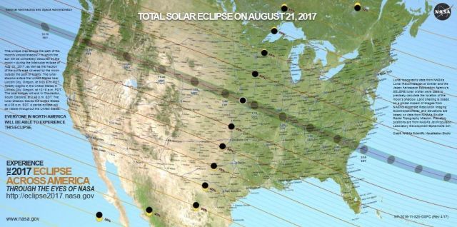
NASA has constructed an animation with the path and the reduction of incoming solar radiation during the eclipse. Below is the shadow at the point where the eclipse will last longest.
.png)
We will continue to update the forecast all this week as the event gets closer.
Notes
The solar eclipse of March 9, 2016 was captured by the Himawari Satellite, operated by the Japan Meteorological Agency. Here is a still image of the shadow over Southeast Asia.

The loop was captured by the Boise NWS office and the link on Twitter is here.
It is reported that from the ground, it will look like twilight outside. You'll be able to see stars. Four planets will be visible - Venus, Jupiter, Mars and Mercury. That is if nature cooperates with clear skies!
Additional information