Final November-March Forecast 1 year ago
October 31, 2024
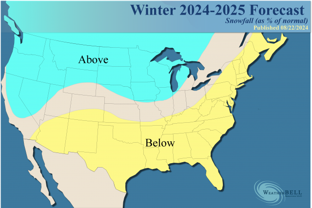
- The final forecast issuance leaves the hand-drawn map the same as the forecast from earlier in the month but adjusts the HDD totals.
- There are indications that it could be colder in the central and eastern U.S., and we compromised between the first two forecasts for the HDD totals.
- A warmer than normal East and South is expected for the Winter Season overall.
- A cold Canada will set the stage for impactful cold air outbreaks.
- Rapid cooling of oceans may throw a monkey wrench into things.
- The active late Hurricane season means to look for a cold outbreak from late November into December and possibly again from December into January.
- The pattern over North America should be in line with recent high-impact hurricane seasons and cold PDO analogs.
.png)
Temperature analog:
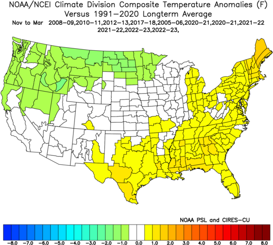
This is backed up strongly by the weak La Niña analog. I have used the 1951-2010 normals as they are inclusive of most of the years:
.png)
Precipitation analog:
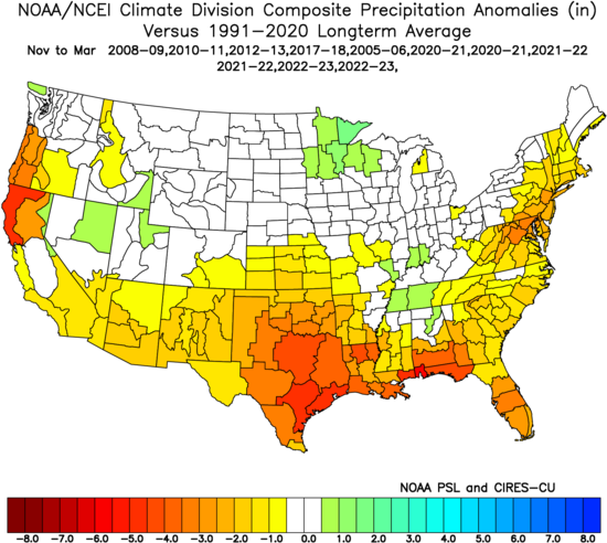
A look at the JMA modeling for the heart of winter follows.
SSTs:
.png)
This is still a negative PDO, which is a warm signal for much of the East and South, with a weak La Niña.
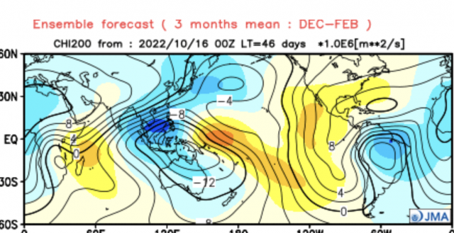
The vertical velocity pattern:
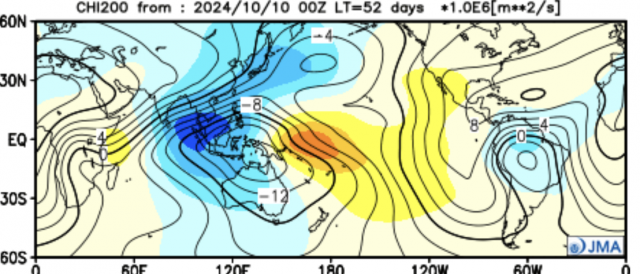
Like two years ago, I am faced with two pigs fighting in a pig sack. The Atlantic has the look of a cold Phase 8, but the Pacific looks like the warm Phases 4 & 5:
.gif)
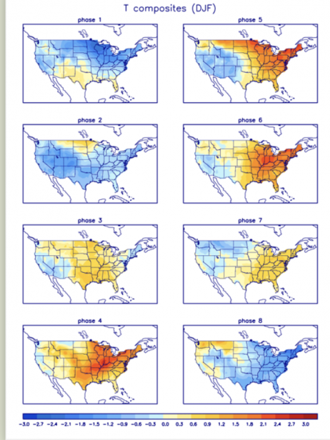
So the result would be warmth outdueling cold, but cold air will try to make some inroads. The active late hurricane season argues we should look for an early cold outbreak from late November into December, which we saw happen two years ago before the Eastern Hemisphere took over the global pattern.
We are seeing a strong rotation of the MJO into phases that should produce a late-season burst in the Tropics. It's not unlike 1985:
.gif)
The current MJO forecast:
.png)
The last two weeks of December 1985 had a major cold shot:
.gif)
By mid-January there was a classic thaw:
.gif)
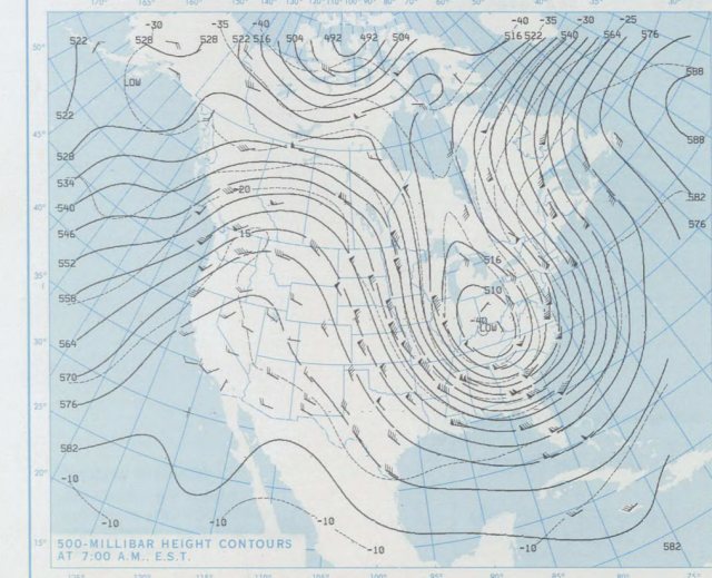
Late January and early February were very cold. The Challenger disaster occurred when an extension of the Polar Vortex dropped into the Southeast:
So that is the kind of high variability that may be on the table this winter. I had a post on WeatherBELL Premium on this you might want to read:
https://www.weatherbell.com/premium/joe-bastardi/makes-you-wonder-how-can-they-be-so-different
It shows the SSTs for 1985 versus now. What we see is homogenous cold in one and warmth in the other (now), with some of the cooler and warmer spots exactly the opposite. So how did we have the same kind of hurricane season and now this rotation?
The Euro 500 mb forecast has evolved. It was like this two months ago:
.png)
Last month:
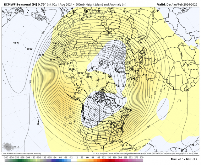
The latest:
.png)
This would allow for a lot of cold air into Canada and possibly penetration to the south when the MJO relaxes or tries to go into the more favored phases.
Canadian:
.png)
JMA:
.png)
Those all suggest that Canada will be cold. Interestingly enough, the analog package I have does suggest enough blocking for cold intrusions, but remember the winter two years ago had blocking but the signals from warmth overwhelmed it.
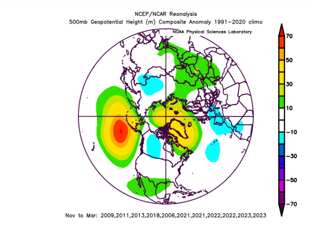
There should be a lot of precipitation in the Heartland, and it will be drier across the South. That implies a snowy winter in the West and northern Plains and there could be a 3-4 week period when it does that in the East, too. I just have a tough time envisioning the cold outdoing the warmth overall. It's interesting in that if there is a high impact mid to late hurricane season that is coordinated with a fast start to winter in December. Remember winter disappeared two years ago after that, and it did last year after the January outbreak.
The Verdict
Overall, we are expecting another winter season with warmer than normal temperatures in the East. With all of the potential for cold air in Canada, there is a threat of major intrusions for a few weeks at a time. Most of the very warm winters have cold intrusions, but the winter comes down to warmth outdoing cold and that is the message here for the East and South. The opposite is likely for the West and North. Snowier than average conditions are expected over the Plains and Northwest, along with much of Western Canada. Snow is going to be a real roll of the dice for areas farther to the East with less than average snow events (as far as an overall number), but one or two big storms can make up for it in amounts similar to 2021-22. Those one or two major events have been completely missing over the past two winters.
With the active late hurricane season having a very strong correlation to early cold outbreaks, likely because the same MJO that can enhance hurricanes now 40-60 days later is favorable for cold, a quick start (mid and late December). Remember, there is no correlation for sustained cold later, and, in fact, it's usually the opposite. It's also interesting how close all of this is running to 1985.