Bastardi- Saturday Summary 13 years ago
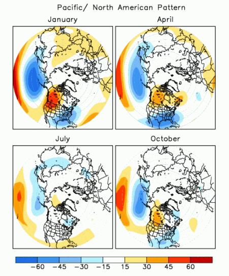
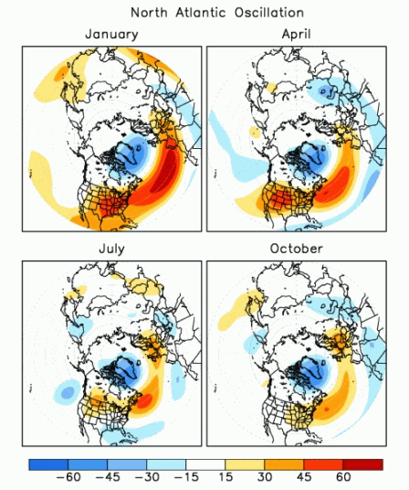
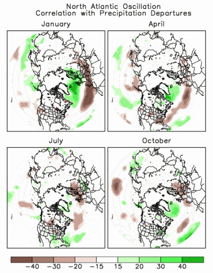
I am going to start here with something you can reference back and forth to. The NCEP Site on temp and precip patterns given the 4 indexes.. MJO, AO, NAO and PNA:
MJO temperatures, January-February-March

MJO precipitation

Latest ensemble runs from various models show us heading into 8
Euro:
JMA (out to 10 days):
.gif)
UKMET
GFS ensemble
.gif)
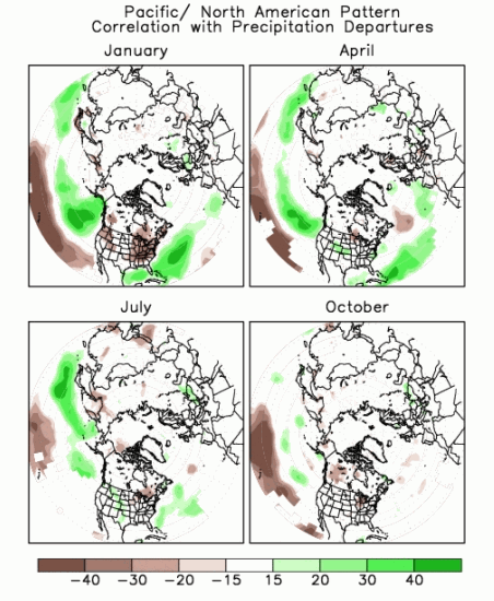
The PNA positive phase gives us this at 500 mb:
.gif)
Precip
The NCEP forecast is strongly positive the next 2 weeks
.gif)
The NAO Map for the positive phase at 500 mb:
with temp and precip:
.gif)
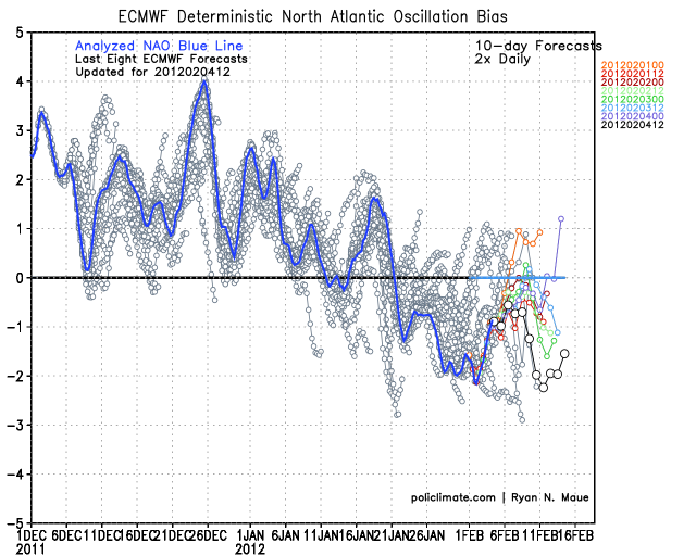
A neutral to negative NAO is forecasted the next 15 days via US ensembles, off Dr Ryan Maues site:
.png)
Euro NAO forecast:
The AO 500 mb composite
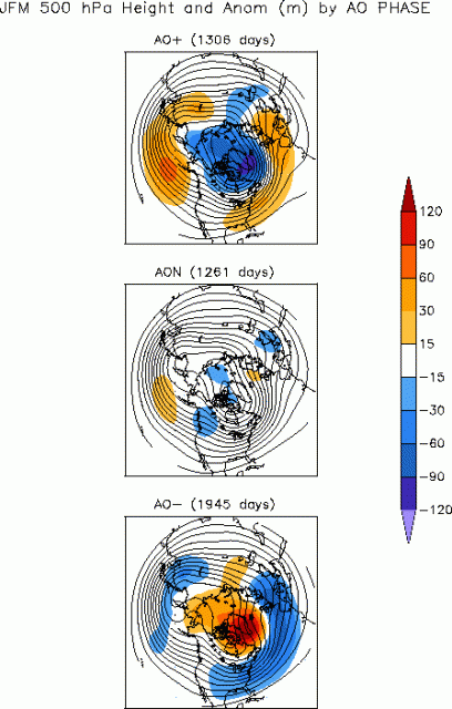
The AO temp map
.gif)
The AO is mainly negative the next 16 days, with the control forecasted off the charts negative, but the ensemble a bit more rational:
.png)
Canadian AO forecast
.png)
In the longer-term, the kajillion dollar question is will the US go the way of Europe where climate models 2 weeks ago had no sign of the major cold that is there now, and something that we at WeatherBELL had been looking for based on the major stratwarm we have been following.
The left was the CFS two weeks ago for Feb, the right is now

I am at major odds with the CFS for Feb and March in the US and the recent model runs of the GFS ensemble are more like my way of thinking.
The below map shows the CFS for Feb and Mar and the GFS at day 14. Given what is in front of us, do not be surprised if the climate model flips as bad in the US in Feb and March as it was just forced to in Europe.

In the shorter term, this week, a wave of low pressure will come out of the Gulf of Mexico with a swath of snow from the Texas Panhandle to the Central Plains Tuesday night then into the Midwest Wednesday and Northeast Thursday. A major storm crashes into the West Coast Tuesday then drops to near the Baja and this is a huge deal as I describe on the video. Should it stay west of Baja, the polar vortex and severe cold will drop into the Lakes, Midwest and Northeast early next week. If it comes out quickly into the Gulf,the then same kind of thing will still happen, but a major storm cold precede it out of the Gulf. As it is the in between solution may mean less extreme this weekend and early next week, but that energy will be heard from and probably mean a major winter event by Valentines Day in the East. The overall pattern is going to get stormy and colder for much of the nation over the coming weeks. There is major blocking locking in, cross polar flow delivering arctic air, and an active storm track for a time into the west with wetter weather in California and the seeds for storms that can deliver snow to much of the nation north of I-40 as the month wears. On the table in a pattern like this is the threat of a shot of severe cold, enough so that Chicago could have a day below 0 and a night that NYC hits 0. The two years in snowed in Rome last, 1985 and 1986, both had arctic outbreaks into the US where temps fell to near 15 below in the southern Appalachians with severe arctic attacks. The stratwarm and the turn to brutal cold in Europe are keys to major global cold outbreaks. and the US is waiting in line. Whether it goes to that extreme or not, is still not perfectly clear but what is clear is that the road to winters end will be bumpier than what has gotten us here to this date.
The JMA and Euro are more bullish than the GFS on the midweek wave and they are accepted. While this should not be a major storm (widespread 6 inches or more) a lot of people from the southern Plains to New England should have accumulating snow in front of the major arctic outbreak next weekend. The set up brings the colder high into the Plains stretching to New England by 72 hours.
.gif)
500 mb
.gif)
Notice the double jet structure developing.
96 hour
.gif)
surface
.gif)
Now, if you want the big storm the problem is we need one strong max, not 2 competing as you see here
.gif)
Still it's enough for a light to moderate event to carry through, but if it was phased over VA, then there is a much bigger storm
.gif)
Before looking at the 12z ensembles, a look at the evolution of the Euro for next Saturday morning, first from 10 days out and how this model has been having major problems with this pattern.
Day 10 valid Saturday from Wednesday
.gif)
Day 9 valid Saturday from Thursday
.gif)
Day 8 from yesterday valid next Saturday
.gif)
Today
.gif)
I explained this morning the "problem" we have with the system over Mexico and how it will work to blunt, to some extent what could happen this weekend. NOTICE YESTERDAY THE MODEL HAD IT WEST OF THE BAJA AND SO THE MODEL HAD THE TROUGH STRONGER. This is so you can see how I am trying to show how important the input of energy from the south is to the overall pattern. The tropics and heat push the temperate regions around when given the chance, and there is a constant war for control of the soul of the pattern.
A look at day 4 in the ensembles shows the trough that may cause the snowfall along with the major system that attacked California from the northwest and then becomes the headache in the pattern over Mexico later.
.png)
Day 8
.png)
As you can see the model is trying to get rid of it, but where and how... If its faster, this is deeper. A call I can't make now, though I suspect that may be our challenge for next weekend!
By day 10 we see the Euro leaned back a bit more on the trough compared to the Canadian and US
The Canadian

This has been a problem with it as we are seeing later next week... too flat.
Day 12 US
.png)
day 16
.png)
The implication of the GFS is that its shifting the onus of the worst part of the global winter weather pattern to our side of the world. It is seeing what should evolve, given the overall pattern and past events similar to this. The WEAKENING of the Nina signal is one that is a reason for the cold end games of la nina seasons, only its starting early this year, as the daily soi is well below what the monthly has been (it was -8 today.. the last 30 days have been plus 9) this indicates that there is a change of the pattern in the tropical Pacific, a source region for the weather. This can be seen here
as one notices the areas of upward motion (green) moving east.. representing lowering pressures and with them the evolution of the MJO toward a more favorable phase for cold over the US.
ciao for now